Sea Level Rise Will Limit Bay Access and Recreation
Sign up for Baykeeper's newsletter
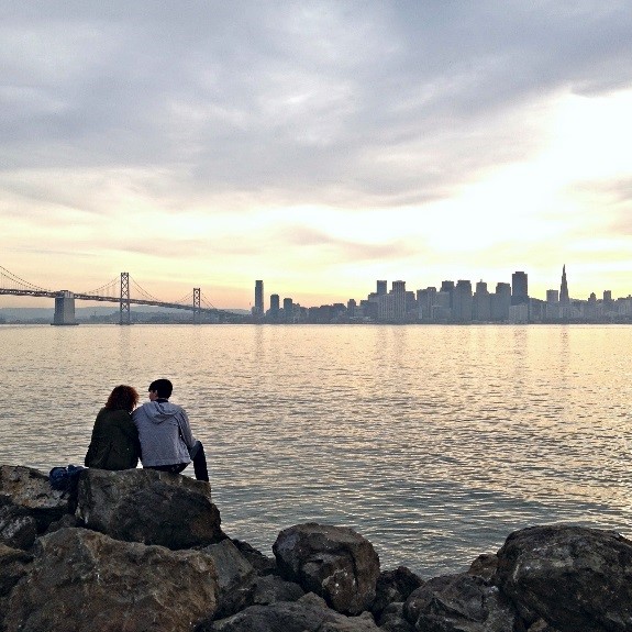
The San Francisco Bay shoreline has over 30,000 acres of open space. Many popular outdoor activities take place near the shore or on the Bay itself. This bounty of scenic recreational areas is a major component of quality of life in the Bay Area, drawing tens of millions of residents and tourists every year. For instance, the Golden Gate National Recreation Area, which includes over 90 miles of Bay and ocean shoreline, hosts 19 million visitors annually throughout its parklands and historic sites. The East Bay Regional Parks District—which includes 15 regional shoreline parks and trails–has approximately 14 million visits per year (East Bay Regional Parks District, 2017). These areas provide direct, low-cost access to the Bay ecosystem and wildlife.
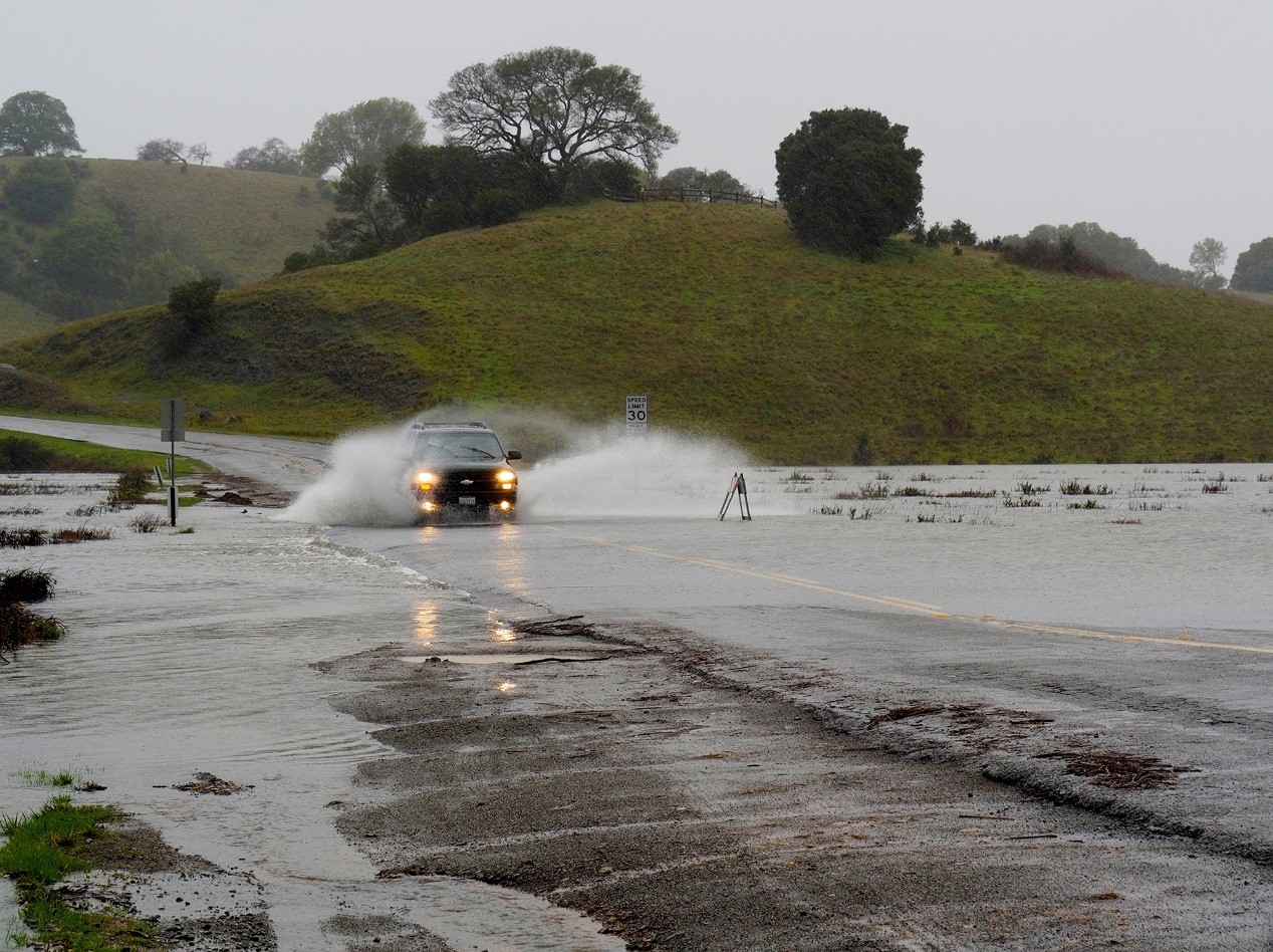
Unfortunately, sea level rise will restrict the accessibility and safety of Bay Area outdoor activities, including water sports, shoreline hiking and cycling, wildlife observation, and access to parks and cultural sites. As sea levels rise, erosion and inundation will shrink many park, trail, and shoreline areas. Essential facilities like launching points, parking lots, and restrooms will be damaged, limiting usability. Water quality will worsen due to increased pollution, raising the risk of harm to people who spend time in the water.
And, as summers become longer and hotter with climate change, demand for Bay and Bay-adjacent recreation will only increase.
Over the coming decades, these factors combined will have a dramatic impact on the outdoor activities we currently enjoy in the Bay Area. For this reason, it’s crucial that local and regional agencies start taking decisive action now to protect the shore and reduce pollution caused by sea level rise.
Shrinking Beaches, Parks & Trails
The most direct impact of sea level rise on Bay Area recreation will be the erosion and inundation of beaches and Bay-adjacent parks and trails. The relationship between sea level rise and erosion goes both ways: sea level rise can contribute to erosion (as higher seas wash away sand, dirt, and paving); and, eroded shorelines—regardless of the cause—are more susceptible to flooding with higher sea levels. The result will be less parkland and smaller beaches along the Bay in the coming decades.
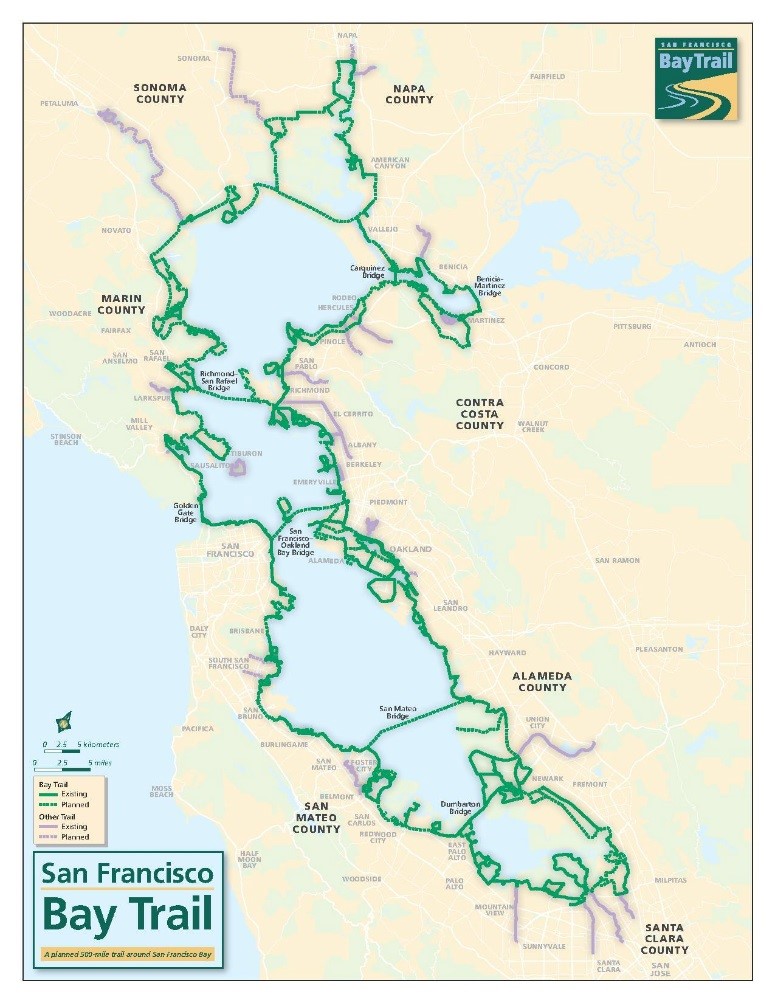
The Bay Trail—a partially completed 300-mile walking and cycling path, and one of the most popular outdoor destinations in the Bay Area—is a good example. The trail winds through all nine Bay Area counties near the shoreline, including through wetlands and nature preserves. Hikers, picnickers, wildlife observers, and even commuters use the Bay Trail. Some low-lying areas of the Bay Trail already flood regularly during high tides or strong storms. This is a strong predictor of flood risk with sea level rise. Projections indicate that particularly vulnerable trail spots at the Martin Luther King Jr. Regional Shoreline Park and the Hayward Regional Shoreline Park will be inaccessible with even moderate sea level rise [see chart, below].

Marshes and wetlands, popular destinations for birders and wildlife observation, will be especially hard hit by sea level rise, since they sit at sea level and are more prone to erosion due to low sediment levels. Sediment (in the form of mud, gravel, dirt, and sand) provides a natural buffer to storm surges and sea level rise. Many shallow tidal wetlands—such as the North Bay’s Suisun Marsh, or the Don Edwards Wildlife Refuge in the South Bay—will become inundated. This will harm the plants and creatures that inhabit them, and inundate nature paths and trails, leaving fewer opportunities for humans to observe and enjoy interactions with the ecosystem. The East Bay Regional Parks system recently analyzed the impact of increasing rates of sea level rise on some of their major parks, in terms of the proportion of park area that would be inundated. Some of the East Bay's most cherished parks would love significant recreational and ecological resources under modest rates of sea level rise.
Learn more about the impact of sea level rise on Bay Area habitat and wildlife.
VULNERABILITY OF MAJOR EAST BAY REGIONAL PARKS TO VARIOUS SEA LEVEL RISE PROJECTIONS
| Park Name | Total Acres | 1 ft SLR | 2 ft SLR | 3 ft SLR | 4 ft SLR | 5 ft SLR | 6 ft SLR |
|---|---|---|---|---|---|---|---|
| Hayward Regional Shoreline | 149 | 86% | 91% | 97% | 98% | 99% | 100% |
| Martinez Shoreline | 158 | 45% | 56% | 62% | 66% | 74% | 78% |
| MLK Jr. Regional Shoreline | 217 | 42% | 45% | 53% | 65% | 82% | 89% |
| Eastshore State Park | 317 | 27% | 30% | 33% | 37% | 53% | 59% |
| Brooks Island/Pt. Isabel | 68 | 14% | 22% | 27% | 30% | 32% | 33% |
| Pt. Pinole | 594 | 13% | 18% | 19% | 21% | 22% | 23% |
| Oyster Bay Regional Shoreline | 187 | 2% | 2% | 2% | 3% | 3% | 4% |
| Miller Knox Regional Shoreline | 209 | 1% | 2% | 2% | 2% | 2% | 7% |
| Crown Memorial State Beach | 80 | 1% | 4% | 11% | 30% | 48% | 65% |
Another at-risk recreation spot is Ocean Beach, one of San Francisco’s most popular outdoor landmarks. Ocean Beach is the most rapidly eroding beach in California due to a number of factors unrelated to sea level rise (like sand mining, which Baykeeper is challenging in court). The erosion of Ocean Beach is expected to increase as large storms become more frequent and increased El Niño activity washes away the beach’s sand. As a result, Ocean Beach is particularly vulnerable to inundation with sea level rise, which will reduce, or even wipe out, a treasured beach area that people have enjoyed for decades.
At another San Francisco landmark, Crissy Field, sea levels have already risen by 8 inches, and rising is expected to continue. In the absence of a seawall or other extreme measures to prevent inundation, Crissy Field may erode away entirely.
Cultural and Historical Sites
The Bay Area shoreline also hosts a number of cultural and historical sites that are popular with tourists and local visitors. These sites, like the parks and beaches that surround them, are vulnerable to damage with rising seas. San Francisco’s Embarcadero and the Civil War-era Fort Point are examples of sites that are particularly susceptible to flooding and erosion with sea level rise, as they already flood during the King Tides—especially high tides that occur annually.
As flooding becomes more severe throughout the Bay Area, local agencies and park districts will have to make difficult decisions about how to respond—and whether to relinquish areas to the Bay and ocean. At Ocean Beach, riprap rubble has been installed at its southern tip to help fend off erosion. At Crown Memorial State Beach in Alameda, which also suffers from a high rate of erosion, park agencies regularly replenish sand to keep the beach intact. However, with rising seas, these strategies will not provide long-term solutions and will become increasingly costly. (BCDC, 2015)
PROJECTION AND ASSOCIATED RANGE OF SEA LEVEL RISE FOR SAN FRANCISCO (INCHES)
| 2000 - 2030 | 2000 - 2050 | 2000 - 2100 | |||
|---|---|---|---|---|---|
| Projection | Range | Projection | Range | Projection | Range |
| ~6 | 1.7-11.7 | ~11 | 4.8-24.0 | ~36 | 16.7-65.5 |
Compromised Recreational Facilities & Infrastructure
While shrinking shorelines and parklands may be the most obvious impact of sea level rise on recreation, the facilities needed to keep public spaces operational are another major vulnerability. These facilities include restrooms and septic tanks, roads, parking lots, piers, launching points, electrical power grids, picnic tables, and equipment rental storefronts.
Many of the facilities serving shoreline areas that are necessary to keep recreational areas accessible and safe lie at or just above sea level. For instance, about half of restrooms in Alameda County parks will be flooded with 16-inches of sea level rise –which is projected to occur by the latter half of the century—plus a major storm. Not only would restroom flooding potentially pollute park areas with raw sewage, agencies would be forced to pay for costly repairs and cleanup—or close parks to the public. Several Bay Area park areas have already invested in portable toilets to prepare for this eventuality. At others, like Stinson Beach, septic systems are being moved to higher ground (National Park Service).
The flooding of roads and parking lots would also make park and shoreline access impossible for many visitors—particularly in more remote areas where public transportation is not readily available.
Eroding Launch Points
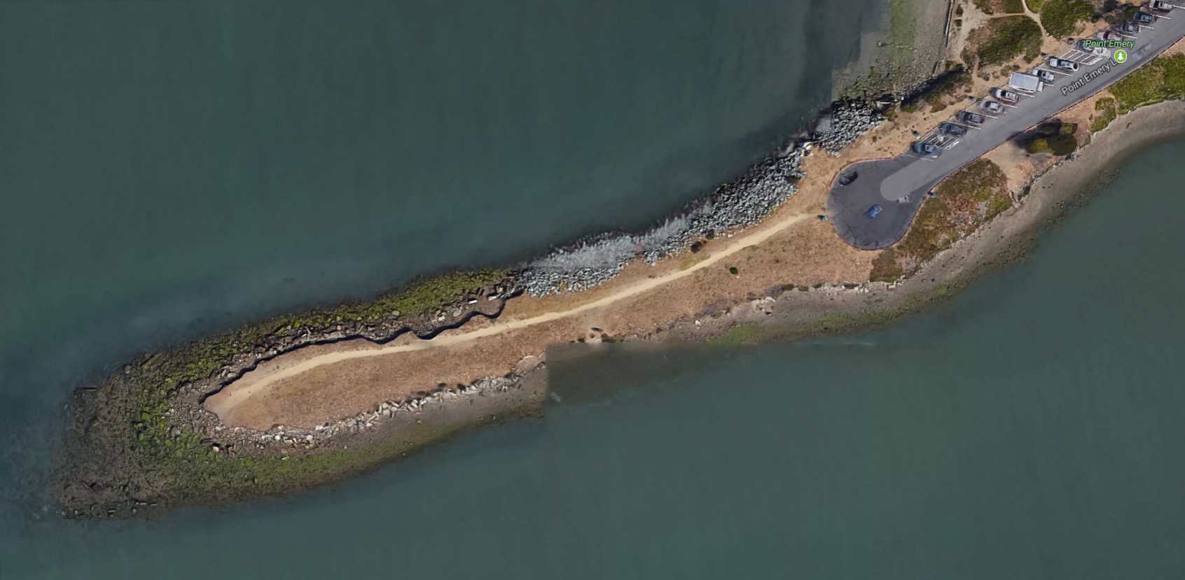
Water sports enthusiasts will face additional complications, since rising water levels will affect where and how people can safely enter the Bay. The shore of San Francisco offers limited entry points into the water that are safe and accessible for swimmers, kiteboarders, boaters, and paddlers. Since launch points are located at the Bay’s edge, they are particularly vulnerable to flooding. Areas with high levels of erosion will become less suitable for swimmers, kiteboarders, boaters, and paddlers to enter the Bay. For example, the popular launch point at Point Emery in Emeryville will likely experience moderate to high levels of erosion with 16 inches of sea level rise at high tide, making it unusable at high tide and during stormy weather. As seas continue to rise, the Point will not be accessible even during low tides. (BCDC, 2012)
Decreased Water Quality
The most serious sea level rise threat to water sports enthusiasts is to their physical health. Many hazardous waste hotspots, industrial facilities, and sewage utilities are at risk of inundation with sea level rise. Flooding of contaminated areas would spread pollution throughout the Bay, risking the health of people who spend time in the water. This Shoreview article explores in depth the Bay Area industrial hotspots that are vulnerable to flooding.
The Future for Access and Recreation in and Along the Bay
Shoreline areas provide immense value to communities, wildlife, and the economy. Open space along the Bay will also take on a greater function in the years to come, serving as buffers against sea level rise encroaching on cities and infrastructure. For this reason, planning agencies must protect these areas from development as well as from sea level rise itself to make the Bay Area more resilient.
Unfortunately, a certain amount of damage from sea level rise is inevitable. Many low-lying areas already regularly flood during the rainy season and King Tides, and these spots will experience increased erosion and inundation in the coming years.
However, there are achievable steps that can be taken to prioritize and protect critical areas, manage resources like sediment to maintain our natural areas, and provide buffer areas for the landward migration of wetlands.
References & Additional Resources
San Francisco Bay Conservation and Development Commission (BCDC), Adapting to Rising Tides: Preserving Shoreline Parks in the Face of Climate Change. 2015.
BCDC, Adapting to Rising Tides: Vulnerability and Risk Assessment. 2012.
East Bay Regional Parks District, Quantifying our Quality of Life: An Economic Analysis of the East Bay’s Unique Environment. 2017.
National Park Service (NPS), Adapting To Climate Change in Coastal Parks: Estimating the Exposure of Park Assets to 1m of Sea-Level Rise. 2015.
NPS, Golden Gate National Recreation Area Climate Change Tour.