Sign up for Baykeeper's newsletter
Active and legacy industry along the Bay shore poses a pollution risk as rising seas flood contaminated lands
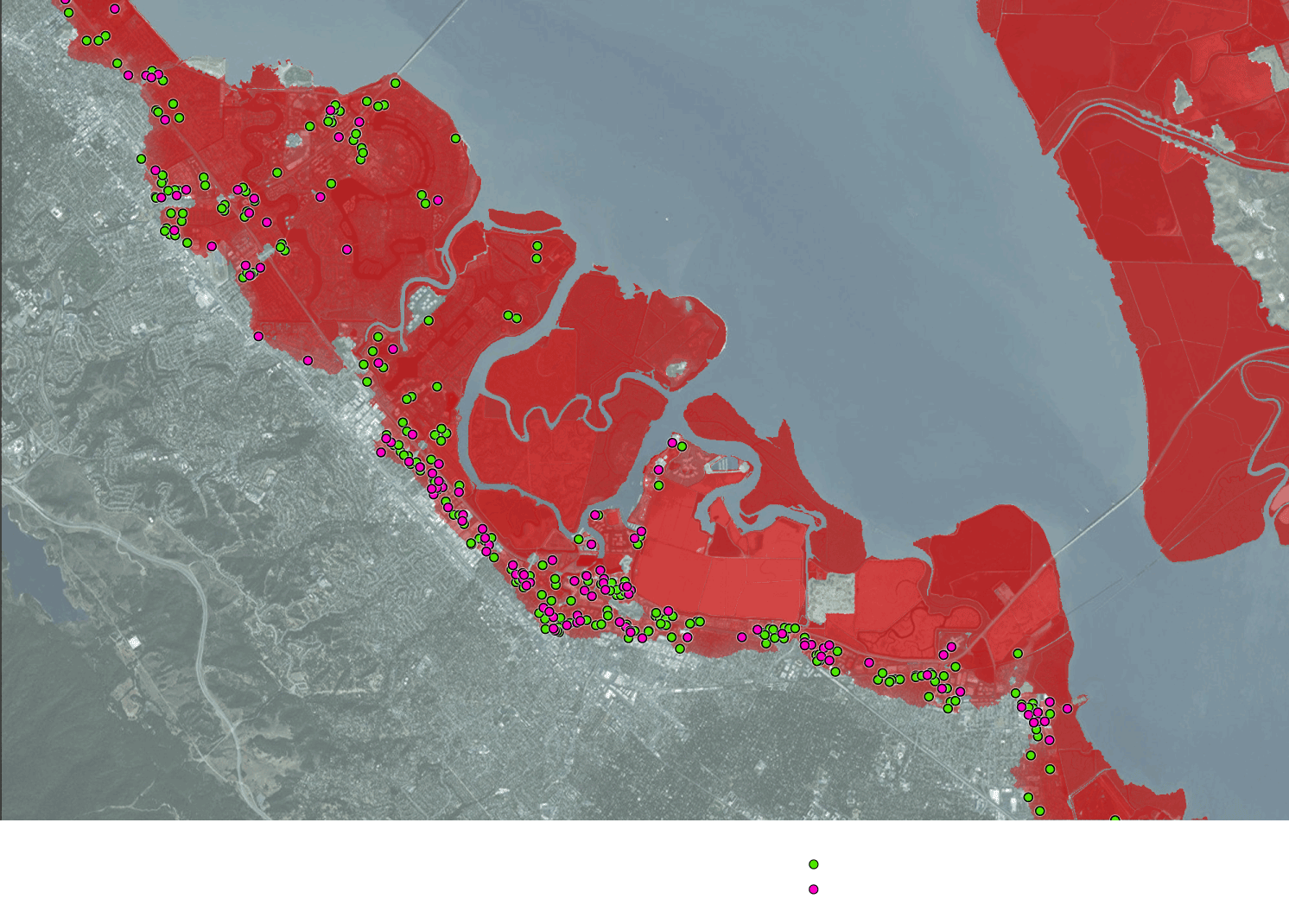
Hundreds of active industrial sites and over 1,000 known or likely contaminated historic sites will be subject to flooding with a 1 meter (~3 foot) rise in sea levels. Few policies are in place to plan for risks to communities and wildlife as seas rise and storm surges inundate these sites.
Like many other urban areas, as the Bay Area developed, industries formed along much of its shores. Manufacturing facilities, refineries, food processing, and shipyards lined the Bay in areas like Vallejo, Richmond, Oakland, and southeast San Francisco.
Baykeeper analyzed publicly available data to identify locations where heavy and light industry are likely to flood under current projections.
Conservative estimates indicate we can expect at least 1 meter of sea level rise by 2100, and flood prone areas will likely be submerged by strong storms. As shown in the map below, a majority of the industrial facilities in the Bay Area are clustered along the shoreline within or near areas expected to flood—raising the risk of industrial waste leaching into the Bay watershed.
In 2017, Hurricane Harvey flooded numerous heavy industrial facilities and wastewater treatment plants in the Houston, Texas, region. Local, state, and federal authorities had not planned for flooding on that scale, and the deluge resulted in the spread of huge volumes of toxic industrial contamination.
In the Bay Area, increased El Niño storm intensity, coupled with sea level rise and the threat of earthquake-borne tsunamis, will almost certainly result in widespread flooding and the release of toxic contaminants from otherwise safe sites.
With the exception of landfills, no other type of active industrial facility or contaminated site in the Bay Area is required to account for the long-term risks of flooding from sea level rise or storm surges. This poses a looming threat that must be managed as the Bay Area prepares for sea level rise.
Legacy Contamination Litters the Bay Shoreline
As industry expanded along the shores of San Francisco Bay in the first half of the 20th century, few were concerned over the ecological and public safety concerns associated with contaminants dumped directly into the Bay or spilled and buried along the shoreline.
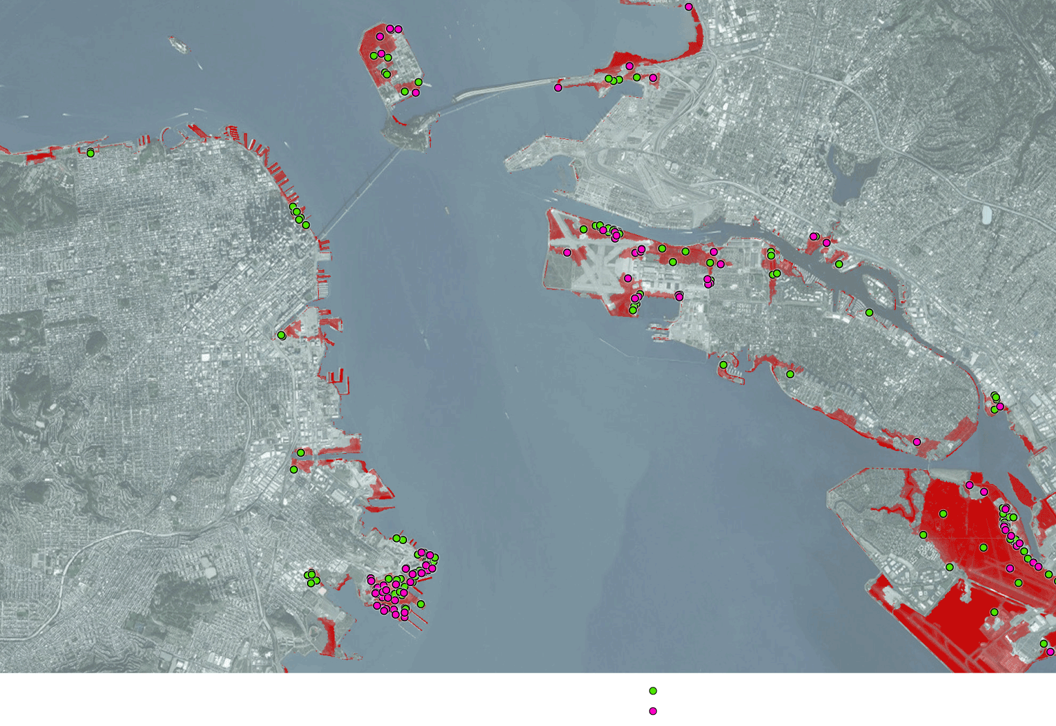
Thousands of known legacy contamination sites are now littered along the Bay particularly in current and former industrial hotspots, including San Francisco, Oakland, Redwood City and Richmondand many have never been cleaned up. This poses a significant liability as seas rise, causing contaminants to leach into the Bay.
Using California’s Geotracker database, there are over 1,100 known or likely legacy contaminated sites subject to flooding in the event of a 1 meter (~3 foot) rise in sea levels coupled with a strong storm.
6 open and 21 closed contaminated sites
within Foster City likely subject
to future flooding in a 100-year storm + 1 meter of flooding
45 open and 78 closed sites
in Redwood City
Contaminated lands in San Mateo County within areas expected to
flood in a 100-year storm, assuming a one meter rise in sea level (red zones)
considered safe under dry conditions
open sites (not remediated)
San Mateo County has the highest concentration of open cases that have not undergone cleanup. Closed sites have been assessed and remediated, though they may still pose a hazard if subject to flooding. Contaminated sites tend to be concentrated in active industrial areas, though some have been converted to office parks, open space, or left abandoned as brownfield sites.
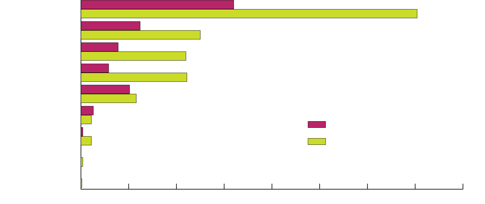
San Mateo
Alameda
Santa Clara
Marin
San Francisco
Contra Costa
open cases (unassessed and/or not remediated)
Solano
closed cases (remediated or deemed safe under dry conditions)
Sonoma
Napa
0
50
100
150
200
250
300
350
400
| County | Status | Leaking Storage Tanks | Military Sites | Cleanup Project | Land Disposal Sites | Other |
|---|---|---|---|---|---|---|
| Alameda | open | 7 | 25 | 24 | 4 | 2 |
| closed | 60 | 45 | 18 | 2 | 0 | |
| Contra Costa | open | 0 | 7 | 4 | 1 | 1 |
| closed | 8 | 1 | 2 | 0 | 0 | |
| San Francisco | open | 0 | 51 | 0 | 0 | 0 |
| closed | 18 | 40 | 0 | 0 | 0 | |
| Marin | open | 7 | 6 | 10 | 2 | 4 |
| closed | 99 | 3 | 9 | 0 | 0 | |
| Solano | open | 0 | 1 | 0 | 0 | 1 |
| closed | 2 | 5 | 4 | 0 | 0 | |
| Santa Clara | open | 1 | 5 | 27 | 3 | 3 |
| closed | 65 | 18 | 27 | 0 | 0 | |
| San Mateo | open | 16 | 0 | 80 | 1 | 63 |
| closed | 289 | 0 | 63 | 0 | 0 | |
| Sonoma | open | 0 | 0 | 0 | 0 | 0 |
| closed | 0 | 1 | 1 | 0 | 0 | |
| Napa | open | 0 | 0 | 0 | 0 | 0 |
| closed | 1 | 0 | 0 | 0 | 0 |
Many of the region’s former military installations, including Treasure Island, Alameda Naval Air Station, and Hunters Point, maintain the highest density of contaminated sites subject to future flooding. Common contaminants include gasoline and diesel, though known carcinogens and toxins are also found at numerous sites. No assessment has been done of the threat posed from the types of periodic or permanent flooding scenarios expected as seas rise and inundate these sites.
In many cases, sites have been deemed safe under current conditions where surface water or groundwater cannot reach contaminants and transport them to the Bay or nearby neighborhoods. This will not be the case in the future, yet today’s laws and regulations do not take this into account.
In most instances, contaminants at these sites have already leaked out of underground storage tanks or were spilled as part of routine industrial processes. Such risks are out of sight and difficult to identify in the absence of lab analyses and expert assessments. Regulators, including the Regional Water Quality Control Board, Department of Toxic Substances Control, and county agencies tasked with tracking and assessing have few resources to force cleanup.
In many cases of legacy pollution, the responsible parties have long been out of business. Recovering cleanup funds requires complicated forensics into the details of ownership, insurance policies, and parsing out responsibility for pollution among multiple parties. In many instances, sites receive cleanup only when redevelopment proposals are pursued. At that point, costly assessments and cleanup efforts on these brownfield sites are triggered prior to construction approval.
One such example is the Brooklyn Basin redevelopment project, to be located on a former industrial site south of Jack London Square in Oakland. This site was known to host a number of contaminants including hydrocarbons, PCBs, heavy metals and other harmful volatile organic compounds. Prior to construction, 48,000 cubic yards of contaminated soil will be removed from the site and two feet of soil will cover the site to prevent human contact with underlying contaminated soil and groundwater.
Despite the enormous cost associated with this effort, if seas rise to the point where this site is inundated, the remaining pollution poses a significant threat to residents and wildlife. This project was conceived nearly 20 years ago and required a $1.5 billion investment from a Chinese consortium to complete. A number of similar heavily contaminated sites line the Oakland Estuary with no hopes for comparable levels of investment.
Redevelopment of the Hunters Point Naval Shipyard is one of the region’s most notorious attempts to clean up heavily contaminated lands. The San Francisco shipyard closed in 1994 after decades of operation. Among other military operations, the site hosted the Naval Radiological Defense Laboratory, which conducted atomic research and decontamination, resulting in radiological contamination. It was designated a Superfund site in 1989. The site is widely contaminated by PCBs, heavy metals, and hydrocarbon-related pollutants.
In the 2000s, the Navy hoped to pass on the responsibility for remediating the site to Lennar, a private development company, for a 700-acre redevelopment project. In 2011, a court ruling required the Navy to first conduct an environmental cleanup prior to transfer of the site to private ownership. Residential redevelopment is now occurring on lands deemed safe. However, redevelopment of a large portion of the site is still mired in controversy, including falsification of data related to radiation-contaminated soils.
Given that the site lies just above current sea level, serious concerns remain as waters rise and potentially leach contamination to the soil surface and into the Bay.
What can be done to prevent the spread of pollution from contaminated sites?
California has spent billions cleaning up contaminated sites throughout the state or compelling entities to clean up legacy pollution. The aim of current programs is to remediate contaminated areas to a standard appropriate for dry land. Few have considered the consequences of periodic or permanent inundation due to flooding and sea level rise in terms of environmental and human health threats.
Agencies can take proactive steps to plan for future risks, clean up existing sites, and require protections from facilities known to handle toxic contaminants.
For specific recommendations for preventing pollution from industrial facilities and contaminated lands, please see our Recommended Actions page.
Sources
Sea level rise model results were taken from the Our Coast Our Future project, which relied on USGS outputs from the Coastal Storm Modeling System (CoSMoS) project. Information regarding existing industrial facilities was found from the CA State Water Resources Control Board's CIWQS database. Contaminated lands data was downloaded from the Water Board's Geotracker site.