Cars stopping when San Francisco Bay water washes onto roads. Waves breaking on pedestrian sidewalks. Water flooding onto polluted oil refinery shorelines. It all happens during the year’s highest tides—and could happen daily as global climate change causes sea levels to rise.
In the years to come, Bay Area shorelines will be at greater risk of the kind of flooding now only seen during the yearly high tides known as “king tides.” The Bay will also be at increased risk of contamination, due to water levels reaching more pollution sources.
King tides took place in mid-December and will return from January 10 to 12. These high tides aren’t caused by sea level rise, but by the gravitational pulls of the sun and moon reinforcing each other. However, king tides can help us visualize where the Bay’s shoreline is vulnerable to rising water.
The year’s highest tides vary from year to year, but the long-term trend is higher water. These dramatic photos, taken from the air during record-high 2015 king tides, show examples of shorelines flooding around San Francisco Bay.
Smart planning can make a difference as sea levels rise. One way to protect vulnerable shorelines is to stop all new development on land that could be underwater in a decade or two. Another is to preserve and build up the Bay’s wetlands. Wetlands absorb water like a sponge, which can prevent or reduce flooding. Baykeeper is helping cities and counties around San Francisco Bay protect wetlands and prepare for sea level rise.
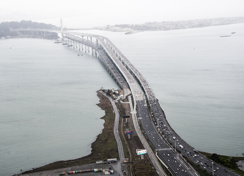
The Highway 80 East Bay approach to the Bay Bridge during the year’s highest tides. Most nearby land is underwater, with only a small strip of land between the highway and the Bay visible.
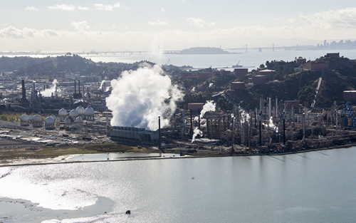
San Francisco Bay washed onto the grounds of the Chevron oil refinery in Richmond during king tides. When the tide ebbed, the water washed back into the Bay. As rising sea levels reach shoreline industrial facilities and sewage treatment plants, the risk of pollution washing into the Bay increases significantly.
To see more King Tides photos, click here.
Photos by Robb Most. Thanks to LightHawk Conservation Flying.