The highest tides of the year take place this week, giving the Bay Area a preview of what’s coming as global climate change raises sea levels.
These exceptionally high tides are called king tides. They occur when the gravitational pulls of the sun and moon reinforce one another. While not caused by climate change, king tides allow us to visualize now how more frequent flooding caused by rising sea levels will impact San Francisco Bay’s shore and shoreline communities.
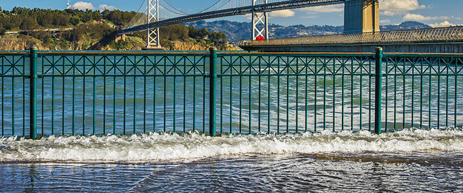
In the photo above, Bay waters wash up on the sidewalk along San Francisco’s Embarcadero during the December king tide, which was almost as high as this week’s high tide. In December, streets in Sausalito and other Marin coastal communities flooded, along with shoreline roadways and parking lots in South Bay. As sea levels rise over the coming decades, this type of flooding will happen more and more frequently.
Climate change is also bringing more severe storms worldwide, like last fall’s Hurricane Sandy on the East Coast. While the Bay Area is not under threat from hurricanes, an intense storm here, combined with higher sea levels, could cause widespread flooding and damage. Damage will be even more severe if a big storm hits when there’s also a king tide.
 Up until 150 years ago, the region’s shorelines had some natural protection from high water storm surges, thanks to abundant wetlands. Wetlands are communities of plants and animals adapted to being underwater or partly underwater at high tide and exposed or partly exposed at low tide. They soak up water like a sponge and stabilize shorelines.
But about 90% of San Francisco Bay’s wetlands have been converted to create farm land, salt production ponds, and urban development. Although some Bay wetlands are being restored, rising sea levels threaten to completely submerge many of these ecologically valuable areas, destroying their protective value.
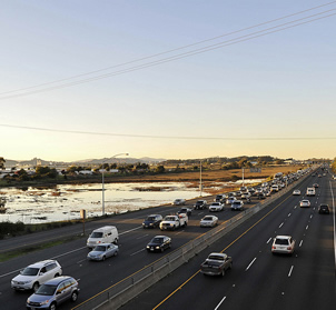
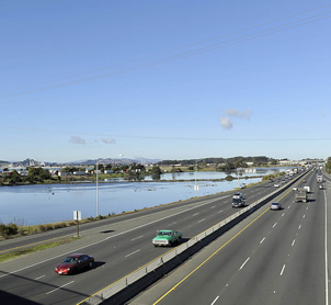 Resilient wetland plant and animal communities may be able to migrate upland and preserve natural protection for shorelines. But the two photos at left illustrate why this won’t be possible for much of the Bay Area’s shore. Wetlands along the Richmond shoreline are exposed at low tide, but completely submerged in a king tide, and the adjacent upland area is paved over with Interstate 80. As sea levels rise, these wetlands and other wetlands all around the Bay will likely be lost.
This damage can still be averted with smart planning. It makes sense not to put thousands of new homes or massive commercial development on land that will be flooded soon. To preserve nature’s flood control protection, our region should also prevent any more development or paving on land just up from wetlands.
Thanks to a recent change in the Bay Plan (the policy that governs urban growth along the Bay’s shoreline), Bay Area communities must now take climate change into account when planning development. Baykeeper advocated for this requirement, and it will likely be enforced as cities consider plans for the former Cargill salt works in South Bay, the proposed Warriors basketball stadium on San Francisco’s Piers 30-32, and redevelopment on Treasure Island. Baykeeper will continue to advocate for planning to protect the Bay, local communities, and the shoreline from sea level rise caused by climate change.
Top photo by Mike Filippoff (Flickr); other photos by tmikkphoto (Flickr/CC)